You don’t need to be a geologist to understand that the world has changed significantly over the years, more so over the last 100 million years.
But in order to show exactly how much the world has shifted throughout this time, scientists have recently calculated this and illustrated it in a 23-second video, creating a remarkable 10-kilometer resolution as a result.
In their rather quick .gif, it explains how so much of the world changed and came to be the way it is in such a short time span. Just take a look at Africa, and you’ll know just how much it has transformed in these last few million years.
In fact, there are particular concepts that look at the bedrock of the earth’s geographical understanding of why the globe looks the way it does. Just take a look at India, which has been on a slow-motion collision course with the Eurasian continent, which actually caused the Himalayas to be created.
But, it’s also hard to imagine exactly how these events manage to change the world by looking at a 2D image of the Earth that remains completely static. However, seeing it in a .gif definitely makes it that much clearer.
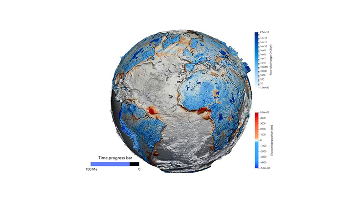
According to the lead author of the paper that presents this exact video, Dr. Tristan Salles of the University of Sydney, “If you look for a continuous model of the interplay between river basins, global-scale erosion, and sediment deposition at high resolution for the past 100 million years, it just doesn’t exist.”
Aside from taking into account the continental drift and plate tectonics, Dr. Salles’ model and illustration also look at the ‘sediment deposition, erosion, and other geological and hydrologic forces as well.’
Meanwhile, in the second portion of the video illustration, the blue shades seen on the continents also show the rate at which the sediment deposition contrasted with erosion. Then as for the way the river flows and the discharge of water, it helped the researchers and students also note how the water managed to change the shape of the planet as well.
Dr. Salles also shared, “So, this is a big advance. It’s not only a tool to help us investigate the past but will help scientists understand and predict the future.”
As for the first part, it measures the way the movement of the continents changed the global topography elevation. For example, the changing shape of Africa showed how West Africa was actually an early addition to the continent.
Moreover, another key to the evolution of the earth was that part of the world is ‘the tugging of what would become the Horn of Africa and the Arabian Peninsula away from the central African basin.’ This is considered a phenomenon that formed the Great Rift Valley, with all of its amazing and glorious volcanic features, which can still be admired up to today.
While the land paths that evolved from this event did allow travel overland from the farthest tip of Asia to the bottom part of Africa, had this not occurred, there wouldn’t have been any Homo sapiens occupying left North and South America.
See the .gif in the video below:
What are your thoughts? Please comment below and share this news!
True Activist / Report a typo